Our Projects
The Haslemere Ecological Network
Preserving Wildlife Pathways: The Haslemere Ecological Network (HEN)
This area is made up of 1% aquatic, 31% urban & suburban, 48% woodland, 19% grassland and 2% heathland habitats. Its a haven for wildlife, but movement between habitats can be difficult. Wildlife corridors made up of woody vegetation, hedgerows, stretches of heathland, road/rail verges, rivers, streams and ponds are key to the movement of species in their search for food, shelter and mates. Overlooked and easily damaged, gaps in hedgerows impact species such as dormice, who rarely venture to ground level. Other species cannot venture far from water and a new fence that cuts off a garden pond in an otherwise arid space can block access to a whole terrain.
Just how important links between territories are to animal population health is unknown, but better connections are likely to improve survival rates when habitats are damaged and reduce inbreeding of confined populations. Benefits are potentially exponential and may be key in slowing species decline. The HEN comprises 44 designated wildlife sites of varying international, national and local significance, public open spaces and the corridors connecting them. To protect and enhance the integrity of the HEN, it was essential to first map it and then assess the condition of its key components.
Members worked with Surrey Wildlife Trust to validate the methodology and findings of the HEN mapping project. The work is ground-breaking and a testament to the power of local groups to effect change; taking advantage of expert advice from national organizations and working with professionals on the ground to provide high quality, cost-effective solutions.
With no previous protection in place for wildlife corridors, the role of Neighbourhood Plan biodiversity policy H12 Protecting and enhancing biodiversity through the HEN is critical. Future phases of work will involve on the ground volunteers, as the network is ‘ground-truthed’ and weaknesses (e.g. broken hedgerows, blocked streams) identified and strengthened. If the HEN is found to positively contribute to local biodiversity, it will be expanded into neighbouring areas to enable species to move and flourish.
The funding that made this possible came from local organizations; CPRE Surrey, The Haslemere Society, the Lob’s Charity and Haslemere Town Council, to whom we are incredibly grateful.
")
")

Find Your Place in the HEN
To explore the HEN, click ![]() in the top left corner to select and de-select the different elements of the network. It’s a good idea to keep Parish and/or Settlement boundary layers selected as they are there to help users navigate the area. Selecting
in the top left corner to select and de-select the different elements of the network. It’s a good idea to keep Parish and/or Settlement boundary layers selected as they are there to help users navigate the area. Selecting ![]() in the top right corner will open the HEN layers directly in Google Maps.
in the top right corner will open the HEN layers directly in Google Maps.
B-Lines Project
Why are the Area's Natural Spaces so Important?
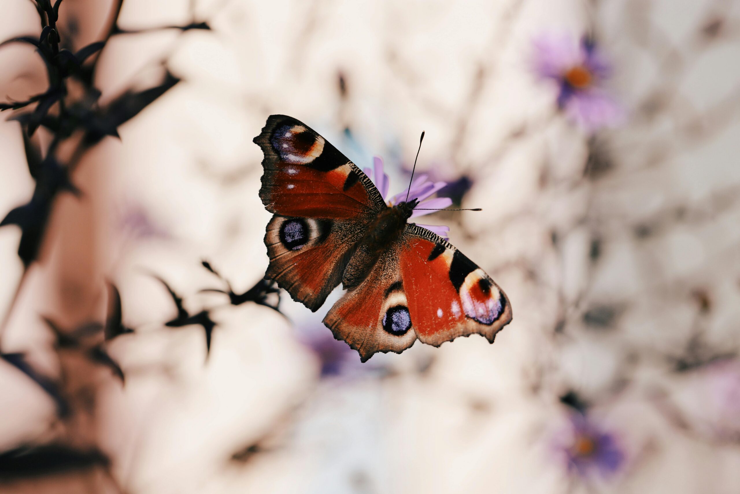
There are huge declines in insect life across the UK, with the annual Bugs Matter survey identifying an 89% decline in England 2022-2023 (as determined by the car numberplate ‘splat test’). Underlying the situation is a 97% reduction in wildflower meadow habits (over 30yrs). Haslemere lies within a major ‘B-line’ or insect superhighway (see map) and we have been working with Buglife UK to identify potential sites for creation/restoration of wildflower meadow habitats. These efforts are to boost populations of pollinating insects and other wildlife and the first site is on Churt Road.
Work began to establish a 750m long nature conservation wildflower verge adjacent to Churt Road in Beacon Hill, parallel to The Golden Valley in Spring 2024. This project is a collaboration between Haslemere Town Council, the National Trust, Buglife, Haslemere Biodiversity and local residents. The verge is cut monthly around the edges, with the central section left uncut until mid-summer.
Towards the end of summer, the verge’s grass is cut and removed to reduce nutrient levels, followed by harrowing and seeding of a native meadow flower mix in late summer. The seed mix is provided by Buglife, as part of their Surrey B-lines project, which has been running since 2020. The grass-verge will be cut and collected on an annual basis by the National Trust, with a 1-2m edge of the verge cut monthly by Haslemere Town Council, allowing local residents to walk around the verge.
Watch out for the Blue Hearts on the verge (installed by local residents and Haslemere Biodiversity volunteers) and following the community seeding event in late-summer, for wildflowers beginning to establish a habitat over the next couple of years. It is hoped further sites can be added in the future.
Impactful Initiatives: Campaigning for Change
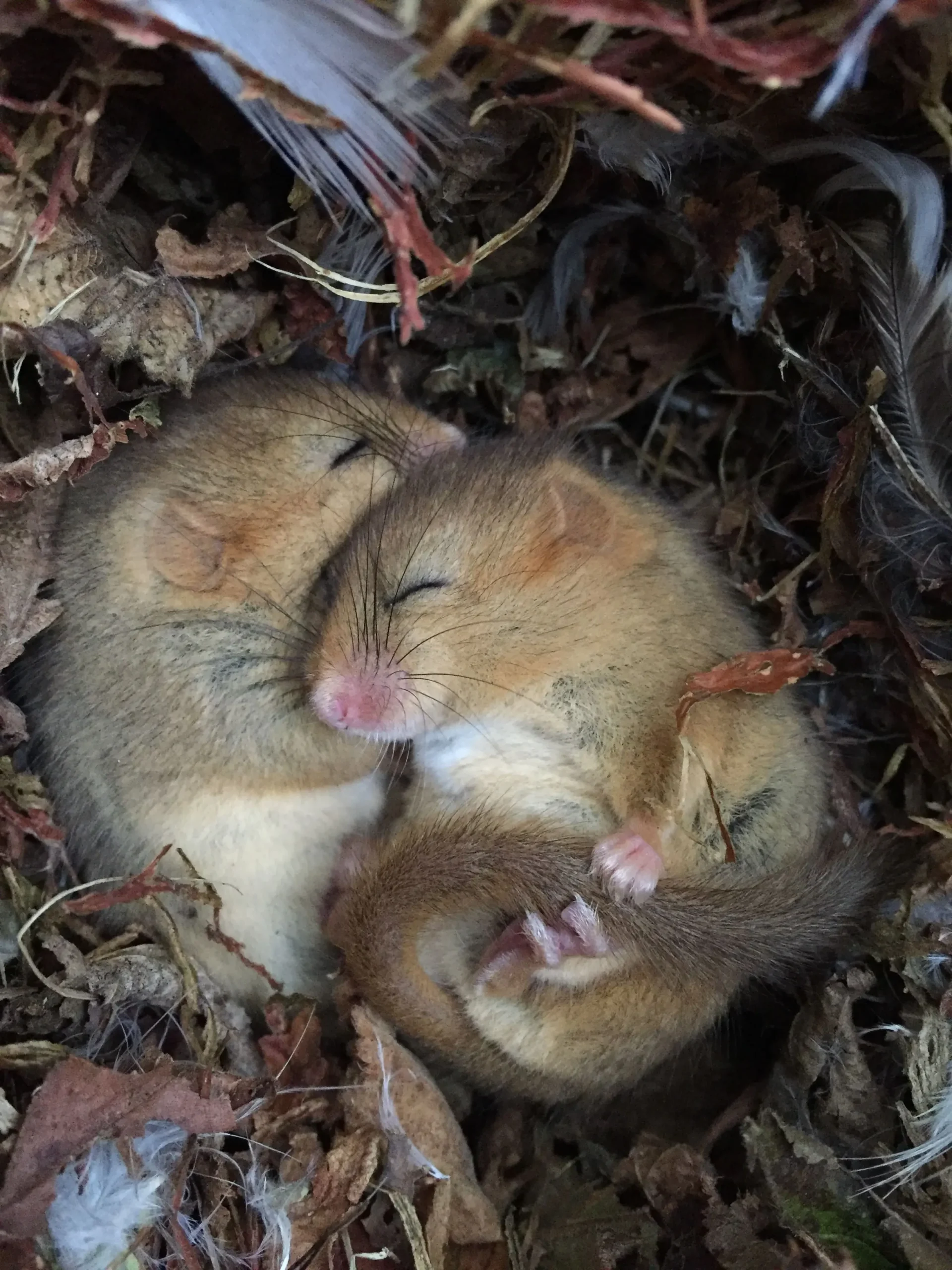
Haslemere Dormouse Project
Haslemere is a ‘hot spot’ for the European or Hazel dormouse (Muscardinus avellanarius) which is now a seriously endangered species. We are working with the Surrey Dormouse Group, local landowners and volunteers to monitor populations and determine the types of habitat corridors utilised by this species on the eastern side of Haslemere.
Monitoring first started in 2021 and we are working to collaborate with other local dormouse projects to create the Haslemere Dormouse Register; a comprehensive database of dormouse sightings that can be overlayed onto the maps of the HEN. Findings will inform good practice guidelines for landscape design & management, safeguarding wildlife corridors and promoting biodiversity gain.
River Wey Water Vole Recovery Project
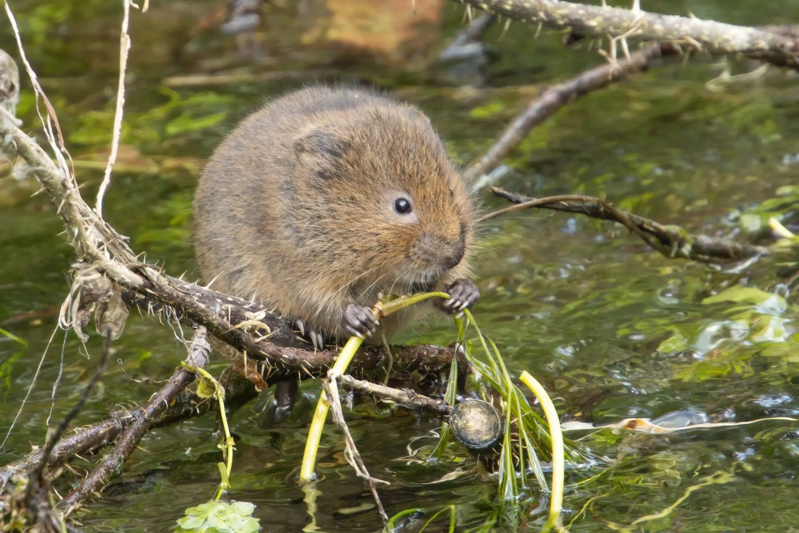
Water voles were historically present along the River Wey in Haslemere through the 1990s and otters have been slowly returning to the catchment, with evidence recorded downsteam in Frensham in 2020 and again within Haslemere Parish in 2021.
To understand habitat suitability for both species, we commissioned ecologist, Andrew Rothwell, to undertake a riparian mammal survey of the upper reaches of the Wey. A series of foot-print rafts were installed along a 5 km stretch and monitored each summer from 2020-2023.
In 2023, we joined a new partnership with the National Trust South Downs team, Wey River Trust, the South East Rivers Trust, Derek Gow Consultancy and others, to support catchment-wide aquatic habitat improvements.
In summer 2024, this work enabled a major milestone: water voles were successfully reintroduced to the upper River Wey. Haslemere became the first release site in a two‑year programme spanning 1,000 km² across Surrey, Sussex and Hampshire. Exact locations are confidential to give these vulnerable mammals the best chance to re‑establish. We hope this begins the return of a species once locally extinct and it reflects years of preparation, collaboration and community support.
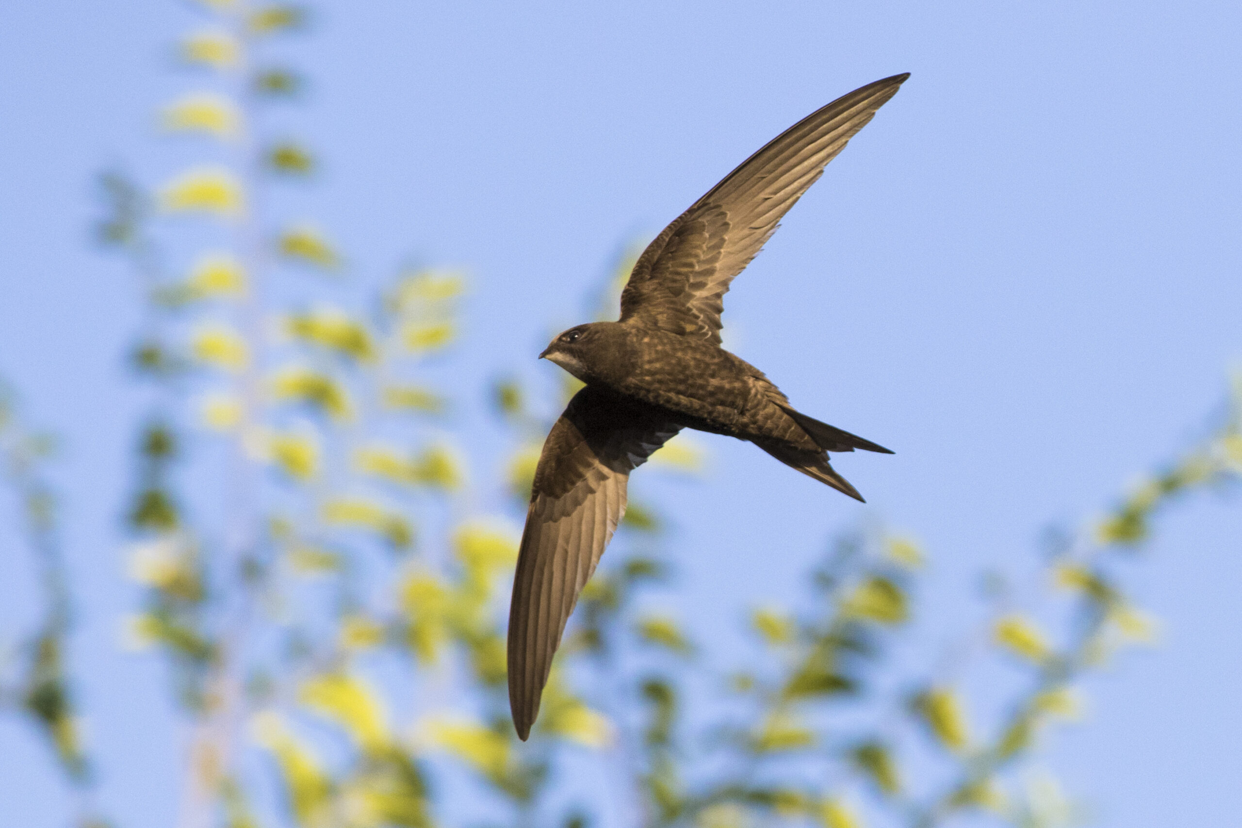
Swift Recovery Project
Since 1994, the South‑East has lost around 68% of its swifts, in the majority due to the loss of traditional nesting spaces in modern buildings. These extraordinary birds spend almost their entire life on the wing, eating, drinking and even sleeping in flight. They return to the same sites each summer, so providing safe nest cavities is essential to recovery.
The project focuses on streets with existing or recently reported swift activity, using local observations and Swift Mapper data to identify where new nest sites are most likely to succeed. By clustering boxes close to established colonies and expanding outwards, a model proven in Winchester and Petersfield, we maximise the chances of new pairs settling. Each suitable home is assessed individually, with volunteer support keeping costs low and attraction calls helping swifts find their new nesting sites
Alongside nest provision, the project encourages simple garden actions, planting wildflowers, avoiding pesticides and creating small ponds, to boost flying insects, the sole food source for swifts. By combining practical habitat creation with community involvement, the project aims to bring these much‑loved summer visitors back to our skies.

A Catalyst for Change
What else does Haslemere Biodiversity Group Do?
- Habitat Enhancement
- Boosting local species in decline
- Monitoring and Measuring our Work
- Creating a Platform for Dialogue and Partnership
- Community Involvement and Volunteering
- Advocacy for Biodiversity Policies
A number of initiatives have been put in place to measure the presence of key species, for example dormouse box chains, riparian mammal observation rafts and pond surveys. These provide baseline biodiversity measurements to demonstrate the impact of work in the future.
Establishing baseline habitat quality and connectivity is also important and we are working with professional ecologists to develop appropriate survey tools and reporting software to measure the existing health and species within wildlife corridors, as well as identifying weaknesses and any improvements needed. Recruitment and training of volunteers is ongoing to support this project. In the meanwhile the corridors are protected from severance by Neighbourhood Plan Policy H12.
The team also review and respond to consultations on national and county level conservation policies. This is an important part of the work as it shapes the treatment of, and investment in, our surrounding green spaces. The tenacity of members in pursuing this work and the hard work of community volunteers in safeguarding and enriching our flora and fauna is what will make the difference in this special place. Join us in our mission to create a thriving environment for future generations.